













About Inyokern
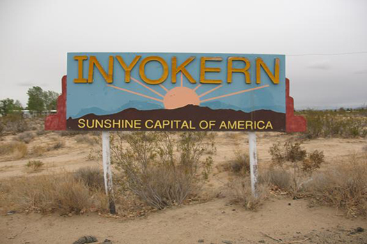
Inyokern is a census-designated place (CDP) in Kern County, California, United States. Its name derives from its location near the border between Inyo and Kern Counties. Inyokern is located 8 miles (13 km) west of Ridgecrest, at an elevation of 2,434 feet (742 m). It is on the western side of the Indian Wells Valley. The population was 988 in the 2020 census, down from 1,099 in the 2010 census. It was a railroad town established along the Southern Pacific railroad's Lone Pine Branch and with WWII became site of the Naval Air Weapons Station China Lake.
Places to visit in Inyokern
-

Red Rock Canyon State Park
Nature · 21 mi from centreSouthwest of Inyokern, this desert park features colorful eroded cliffs and buttes that have appeared in many films. Short trails and scenic drives reveal striking rock formations, best seen in morning or late afternoon light.
-

Maturango Museum
Museum · 8 mi from centreA small museum in neighboring Ridgecrest focused on the natural and cultural history of the northern Mojave Desert. It is also the place to ask about guided tours to the area's famous petroglyph sites.
-
Fossil Falls
NatureA dry waterfall north of Inyokern where an ancient river carved and polished black volcanic rock into smooth chutes and potholes. A short trail leads to the edge of this unusual desert landscape.
Best time to visit Inyokern
Based on recent weather records, the most comfortable time to visit Inyokern is April and October, when average daytime highs are around 77–82°F and rain falls on about 1 days a month.
Average daily low and high temperatures and days with at least 1 mm of rain, from recent weather records. Highlighted months are the most comfortable for sightseeing.
Inyokern weather forecast
- Wed 21 Oct 78° 58° 50%
- Thu 22 Oct 67° 56° 74%
- Fri 23 Oct 67° 55° 5%
- Sat 24 Oct 74° 60° 0%
- Sun 25 Oct 74° 61° 0%
- Mon 26 Oct 75° 65° 1%
Know before you go
- Currency
- United States dollar (USD)
- Language
- English
- Calling code
- +1
- Driving
- On the right
- Time zone
- America/Los_AngelesUTC−7
- Capital
- Washington, D.C.
Upcoming public holidays in United States
- Veterans Day
- Thanksgiving Day
- Christmas Day
- New Year's Day
- Martin Luther King, Jr. Day
- Presidents DayWashington's Birthday
Banks, offices and some attractions may close on public holidays, and flights and hotels often fill up early around them.
Getting to Inyokern
These are the airports closest to central Inyokern. Compare fares into each one, as a slightly longer transfer can sometimes mean a much cheaper flight.
- IYK Inyokern Airport1 mi (2 km) from the city centre
Inyokern travel FAQ
When is the best time to visit Inyokern?
Based on recent weather records, the most comfortable time to visit Inyokern is April and October, when average daytime highs are around 77–82°F and rain falls on about 1 days a month.
What is the weather like in Inyokern?
July is usually the warmest month in Inyokern, with average highs of 103°F (40°C). January is the coolest, with average lows of 38°F (4°C). The wettest month is typically November, with about 59 mm of rain.
Which airport is closest to Inyokern?
Inyokern Airport (IYK) is the closest airport, about 1 miles (2 km) from the centre of Inyokern.
What time zone is Inyokern in?
Inyokern uses the America/Los_Angeles time zone (currently UTC−7). Remember to check for daylight saving changes when planning connecting flights.
What are the best places to visit in Inyokern?
Top sights in Inyokern include Red Rock Canyon State Park, Maturango Museum and Fossil Falls. Southwest of Inyokern, this desert park features colorful eroded cliffs and buttes that have appeared in many films. Short trails and scenic drives reveal striking rock formations, best seen in morning or late afternoon light.